• Mount Kilimanjaro National Park
  • Machame Camp
  • Shira Camp
  • Baranco Camp
  • Barafu camp
  • Mweka Camp
  • Machame Gate
  • Lava Tower
  • Baranco Wall
  • Stella Point
  • Shira Camp
  • Kissing Rock
  • Uhuru Peak
  • Mweka Gate
  • Mt. Kilimanjaro Machame Hiking Route
  • Baranco Camp
  • Machame Camp
  • Barafu camp
  • Mweka Camp
Mweka Camp map

Tanzania Tours Itinerary 7 Days Kilimanjaro Moshi Arusha

Mt. Kilimanjaro Machame hiking Route

You can tailor-make the tour duration, route, themes, and cultural experiences, etc, based on your personal needs & interests.

Tour Duration: 7 Days 6 Nights.   Tour Code: TZ07006  
Tour Themes: Classic

Tour Route: Kilimanjaro - Moshi - Kilimanjaro - Arusha

FREE INQUIRY
Highlights

7 Days Mt. Kilimanjaro Machame Line Hiking Tour

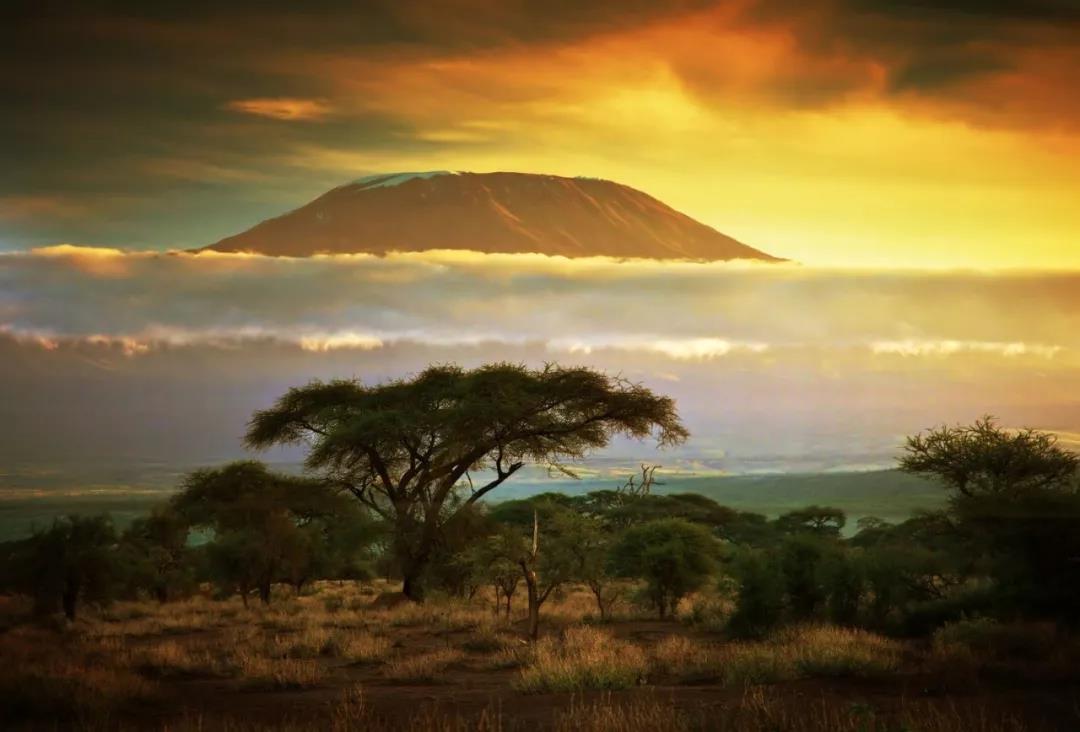
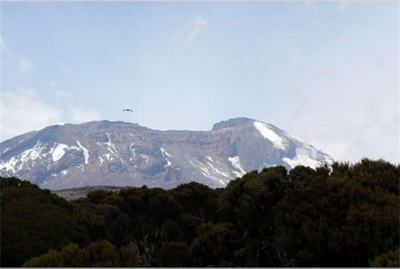
In the past few centuries, Mt. Kilimanjaro has been a mysterious and most magnificent sights in Africa--no one really believes that there is such a snowcapped mountain on the equator, but it has existed for thousands of years.


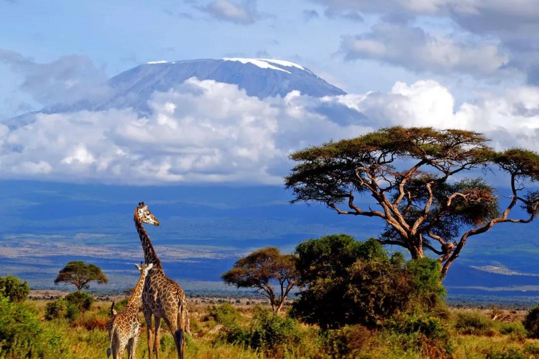
Sending its shadow across Tanzania's northern plains, Mt. Kilimanjaro is one of the world's highest volcanoes, and the highest free-standing mountain on earth. It is also the only peak that can be reached without ropes or technical climbing experience. Therefore, many people choose to climb it as a symbol in their life, the most memorable highlight. 


Non-technical, however, does not mean easy. The climb is a serious undertaking, and only worth doing with the right preparation. 


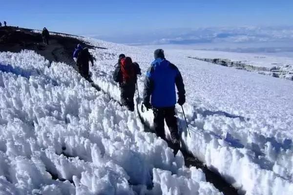
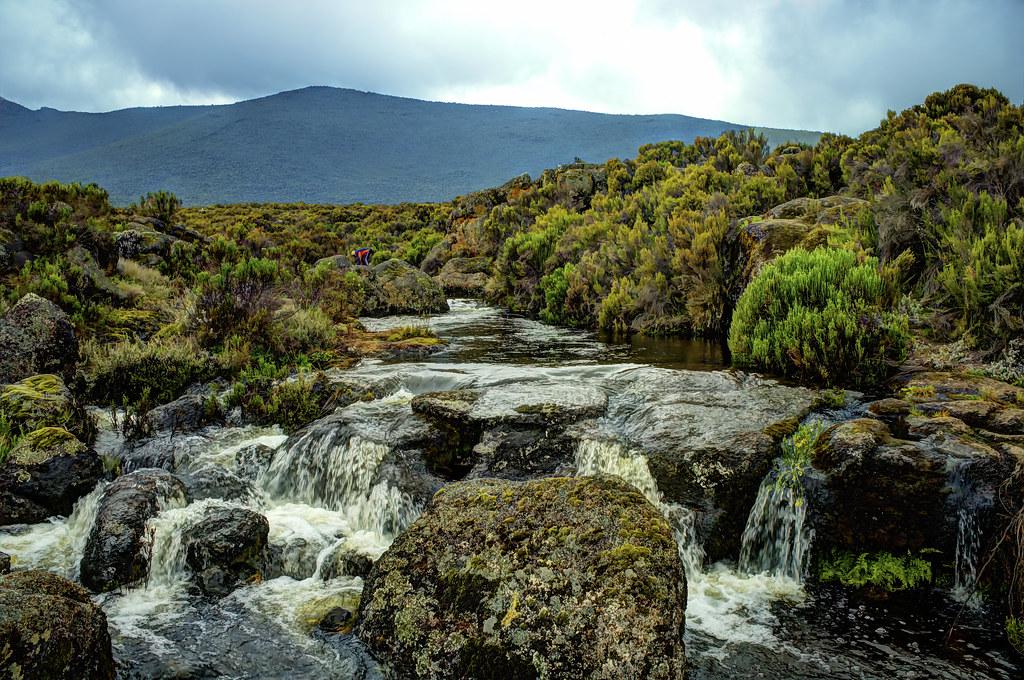
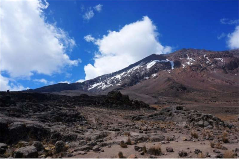
The moutain rise from cultivated farmland on the lower levels, through lush rainforest to alpine meadows, and finally across a lunar landscape to the twin summits of Kibo and Mawenzi. In addition to the challenges of climbing,  these flora and fauna along the way, the bright starry sky, the ice field on the top of the mountain... the ever-changing landscape from the equator to the North Pole are all The precious memory that is unforgettable in this journey. it is to be remembered for a lifetime!


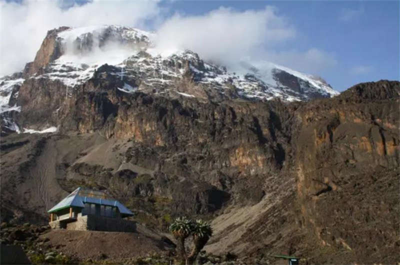
The melting snow has formed lakes and Wetlands at the foot of the mountain, which is very suitable for elephants to live. And there are more than 400 species of birds living here at the same time.  it is now a veritable bird watching spot in East Africa.


======================================================================================================================================

Hiking Route

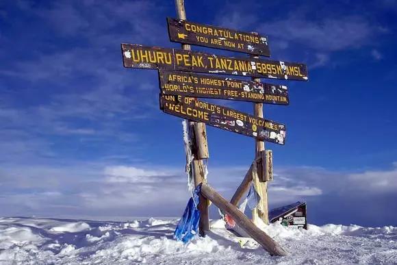
Mt.Kilimanjaro has two main peaks, Kibo and Mawenzi. They are connected by a ridge over 10 kilometers long. The usual climbing destination is Uhuru peak on the Kibo, 5895 meters above sea level. Although Mawenzi Peak is lower, but it is said to be much more difficult to climb.

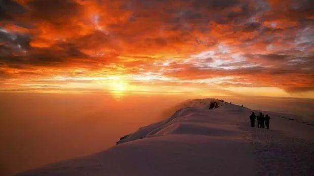
Why hiking Mt. Kilimanjaro? The rewards: the thrill of standing at the top of Africa; magnificent views of Kilimanjaro's ice fields; and witnessing sunrise illuminating the plains far below.


What is "Whiskey Line" and "Coca-Cola Line" when it comes to climbing Mt. Kilimanjaro? 

In fact, there are six hiking routes to reach Uhuru Peak:

Marangu line(also known as the Coca-Cola route), 

Machame line (also known as the Whiskey route), 

Rongai line, 

Umbwe line, 

Shira line, 

Lemosho line.


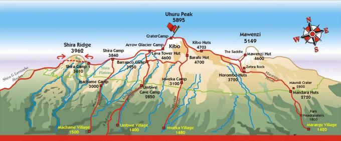
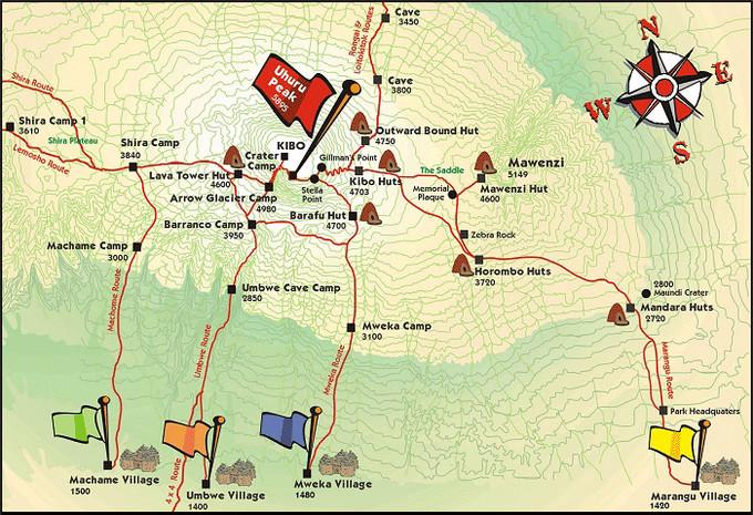
MARANGU Line (the Coca-Cola Line):

Among the six routes, this one is the most frequent and the easiest route to reach the summit. The 5-day journey is the lowest cost hiking route also. Passing through camping sites of Mandela, Huolombo,  Kibo, and reaching the highest peak "Uhulu Peak". Only this one of all routes can live in a comfortable shed hut every day, and you can buy mineral water, beer, chocolate and Coca-Cola there. So this line is also called the "Coca-Cola" line. This is currently the main route and the most popular route for tourists. 

MACHAME Line (the Whiskey Line):

It is a popular route second only to Marangu and the most beautiful route! This 6-day hiking journey is physically more challenging than the Marangu route. However, this route allows climbers to see the main peak of the volcano. -The entire south side of KIBO. Pass through Macham Camp, Hilla Camp, Barranco Camp, and Balaf Camp to reach the highest point. This route can only provide tent accommodation. The distance is longer and the climb level is more difficult. Not everyone can challenge it, so it is called the "Whiskey Line".

RONGAI LINE:

Very steep route to the summit. This is the only route to climb from the North Slope. It is similar to the Marangu route, but there are places in this route that require overnight stays in tents. On the sixth day, there is a chance to see Mawenzi Lake and the northern ring crater of Mawenzi. Climbing Kilimanjaro is an experience worth remembering in a lifetime, so those who are adventurous and want to have a great experience are recommened to try this line..

LEMOSHO LINE:

This is the relatively remote and difficult route among all routes. It is also a pristine and very beautiful route to the top of Africa. The Lemosho Meadow is surrounded by a jungle. There are a large number of  foraging animals in the jungle, such as elephants/African buffaloes. Therefore, guards are required to accompany them on the first day of climbing for the safety. This is a long route to the summit, which takes about 7 days, so the cost is relatively high.

UMBWE LINE:

This is a shorter route to the summit of Uhuru, but also a relatively difficult route. This 6 days' route is very attractive. It is famous for its caves. You will live in the Umbwe cave camp on the first day of the trip, and encounter more than 2 cave camps during the next few days' trip. Sometimes it is also used as a route down the mountain. This route can only provide tent accommodation. The journey is not long, but the climb difficult level is high . It is best to have cave camping experience.

SHIRA LINE:

The steep route from the west slope to the Kibo crater. Due to its remote location, there are fewer tourists on this route. It takes 2-3 hours to drive from Moshi Town to the climbing site. An additional benefit is that you can see a very magnificent animal landscape on the first day of the hike. Of course, you need to have guards accompanying you for your safety on this day. We recommend this route because it is relatively quiet, you rarely see other people in the first four days, and it gives you more time to adapt to the climbing environment. This route is only suitable for physically strong people and those with mountaineering experience.

Hiking season

The best hiking season here: warm and dry season, June - October; December - March.


Day 1 Kilimanjaro Moshi Arrival

Arrived at Kilimanjaro Airport in the afternoon, drove to Moshi Town, and drop off at the hotel to rest and adjust the time to prepare for the climbing tomorrow.

Day 2 Moshi Kilimanjaro

Departing from the hotel in the morning, after driving for 20 kilometers, you will arrive at the gate of the National Park and enter the village of Macham. It started out as a primitive mountain forest, full of impatiens, begonias and other ferns lays like carpets in front of you. After 6 hours of slow climbing and adaptation, we finally arrived at the Macham Camp at 2,980 meters to rest.

***On the hiking way, you will find these little hut standing near the trail at low land. they are the toilets. surprisely, they are very tidy and clearing.  But the closer you are to the top of the mountain, the simpler the facilities, some even just a dirt pit.

If you wish to have your own toilet, it can be arranged too. a portable one will be carried together with other equipment along the way to the last campe site.  

Accommodation: Tent
Meals: Camp breakfast, road meal, camp dinner
Altitude change: 915m-2980m
Kilometers and time on foot: 12km, 6-7hrs

14290Mount Kilimanjaro National Park
14343Machame Gate
14291Mt. Kilimanjaro Machame Hiking Route
14345Machame Camp

Day 3 Kilimanjaro

Departing early in the morning, if you are lucky,  you will see herds of big antelopes along the way, climbing to the volcanic crater.  The strange geological features here are fascinating. From the time when the tall Dendrosenecio appeared, you have walked out of the alpine meadows. Camp in the Sheila at an altitude of 3840 meters.

***Every day after arrive at the camp, there will be a small basin of hot water for you to wash our faces and hands. Mountain water is precious, if there is extra water for your feet, that is luxury already,  so don’t expect showers at all.

Accommodation: Tent
Meals: Camp breakfast, road meal, camp dinner
Altitude change: 2980m-3850m
Kilometers and time on foot: 7km, 5-6hrs

14345Machame Camp
14347Shira Camp

Day 4 Kilimanjaro

Wake up & departure in the early morning from the Shira camp, all the way is semi-desert and rocky landforms, after about 5 hours of climbing to another level at the Lava Highlands, you must begin to adapt to the alpine climate. The rocky ocean of volcanic rocks lies in front of you and the mark of  glaciers are faintly visible. it's a scenery usually seen in the Science fiction film. It is a hard day. Most climbers start to have altitude sickness. after nearly 2 hours of descent in the afternoon, you will reach the Barranco Canyon at 3950 meters and camp.

***Dendrosenecio kilimanjari, it is an endemic plant of Kilimanjaro, which grows in the area of 3,600-4,300 meters above sea leavel. Its height is generally above 3 meters, and the highest can reach 10 meters. The leaves are clustered on the tops of the branches,  like big cabbage; at this altitude, the temperature will drop below zero every night. In order to keep warm, the top leaves will close at night and roll inward to protect the young buds, and then reopen when the sun comes out the next day. And to keep the trunk warm, the withered leaves are hanging there without falling, forming a thick layer to protect the stem inside. 

Accommodation: Tent
Meals: Camp breakfast, road meal, camp dinner
Altitude change: 3850m-3950m
Kilometers and time on foot: 13km, 7-8hrs

14347Shira Camp
14348Lava Tower
14349Baranco Camp

Day 5 Kilimanjaro

Today, you will climb all the way up the tortuous mountain road with picturesque scenery. you can overlook Moshi Town from the campsite in the morning sunshine. Passing through the steep Barranco Canyon,  overlooking the magnificent glacier scene, admiring Kili close at hand. After adjusting at the Kalanga Canyon Camp, you will continue to climb upwards,  and then went all the way north to reach the Barafu Camp. Rest early to prepare for the summit  the next day.

*** Generally, if you arrive at the camp early in the afternoon, usually at 3~5 o'clock.  there is an afternoon tea served before dinner. it includes popcorn, peanuts, fried chicken, French fries, biscuits, coffee, milk, hot chocolate, tea, etc.. 

Accommodation: Tent
Meals: Camp breakfast, road meal, camp dinner
Altitude change: 3950m-4670m
Kilometers and time on foot: 12km, 7hrs

14349Baranco Camp
14351Baranco Wall
14352Kissing Rock
14355Barafu camp

Day 6 Kilimanjaro

Ascenting to summit started at 00:00 in the dark. Five hours later, you will climb to the summit of Stella to watch the sunrise. it is a joyful time when you see the sun rises from the adge of the clouds. comtinue climbing about an hour, you will reach the summit of Uhulu at 5895 meters high. people are excited, chearful even crying for this moment.  

The peak is often covered with clouds and mist, as if covered with a veil. The snow-capped peaks and the huge glaciers winding like silver snakes render here into a crystal clear world. Cheers to celebrate the summit and enjoy the fairytale scenery. Then descend to Maweka camp to rest.

Accommodation: Tent
Meals: Camp breakfast, road meal, camp dinner
Altitude change: 4670m-5895m-3100m
Kilometers and time on foot: 22km, 15hrs

14355Barafu camp
14357Stella Point
14292Uhuru Peak
14360Mweka Camp

Day 7 Kilimanjaro Arusha Departure

Today will be a relatively easy journey, you will continue descending to the park exit Mweka Gate at about 1,700 meters above sea level. Here you will get a summit certificate issued by Kilimanjaro National Park and signed by the mountain guide. And transfer to Arusha together for rest. In the evening, you will have a happy summit celebration with the mountain guide team.

**The one who gives up before the summit will not get the certificate. 

Accommodation: Arusha Hotel
Meals: Camp breakfast, road meal, local dinner
Altitude change: 3100m-1409m
Kilometers and time on foot: 10km, 3-4hrs

14360Mweka Camp
14361Mweka Gate
Visa to Enter Tanzania+

More than 67 countries whose nationals are not required to apply for visa to enter Tanzania. They will undergo immigration formalities at the entry point upon arrival. That include citizens of Cyprus, Kenya, Malaysia, Singapore, South African...

Any foreign national who is eligible for a Tanzania visa is also eligible for a visa on arrival. However, it is recommended to apply for a visa prior to visiting Tanzania. There are different types of visa for Tanzania, as well as a list of countries that must apply for a referral visa, which involves a lengthier screening process.

For more details, please refer to 
https://www.tanzaniavisas.com/visa-on-arrival/

Weather of Tanzania+

Tanzania is located in the tropics, south of the equator, and it is warm all year round. The average temperature is around 22°C-29°C in Dar es Salaam and Zanzibar, and 11°C-22°C in Arusha. But It is usually cool in the morning and evening, There is a big temperature difference between day and night in Tanzania. 

Customize or Get more Details about this itinerary and its Exquisite Professional Proposal for free. Fill in Simple Inquiry below! Save Your Time & Energy!
Adults: Child: Duration: Days

No extra fee!Replied in 0.5-23.5 hrs!